Below is the current errata list for this textbook. These errata will be corrected in the next edition.
For copies marked “Last revised August 2nd 2025”
Updated: 8 September 2026
As I warn earlier in the book, the only sure thing about the Australian IFR system is change. Airways, waypoints, approach procedures and even paragraph numbers have an irritating habit of moving while you are trying to learn them!
The following amendments apply to the current printed edition of the Command Instrument Rating book. They have been checked against the current AIP, ERSA, DAP and en-route information available at the date above. The book itself is the August 2025 revision.
Remember that the object of the IREX is not simply to remember the answers in this book. You must be able to find and apply the information contained in the current operational documents.
Page 97 — Question 6
The airway structure between Bathurst and Mudgee has changed. The purpose of this question is to test interpretation of ADF indications, not your memory of an old airway.
Replace Question 6 with:
Question No 6 — Refer to ERC Low 3
You are flying from Bathurst (332434S 1493907E) to Mudgee (323345S 1493640E) on a flight planned track of 345°M. You have two ADFs fitted. ADF 1 is tuned to Bathurst and ADF 2 is tuned to Mudgee. If you hold a heading of 350°M, the ADF indications that should show that the flight planned track is being maintained are—
(a) ADF 1 reads 355°R and ADF 2 reads 175°R
(b) ADF 1 reads 185°R and ADF 2 reads 005°R
(c) ADF 1 reads 345°R and ADF 2 reads 345°R
(d) ADF 1 reads 175°R and ADF 2 reads 355°R
Answer: (d)
The worked answer on page 100 remains valid.
Page 212 — Bankstown departure example
The Bankstown flight planning requirements have changed.
Replace the example with:
You are planning an IFR flight in VH-OZY from Bankstown to Brisbane at 9000 ft. What would be an appropriate route to plan?
Check ERSA GEN-FPR para 1.4 — Sydney/Bankstown Departures.
VH-OZY is a non-jet aircraft and the departure is to the NORTH. The current requirement is:
DCT KAMBA
From KAMBA, continue via an appropriate current ERC/Flight Planning Option route towards Brisbane.
The old routing via Richmond/V668/MAKOR should no longer be used.
Page 213 — Flight Planning Options
Replace the existing Flight Planning Options examples with the following.
Refer to ERSA GEN-FPR para 9 — FLIGHT PLANNING OPTIONS.
Flight Planning Options may only be used in accordance with the route Flight Plan Requirements contained in the preceding sections of GEN-FPR.
Current examples include:
Wagga Wagga to Sydney
DCT WG W113 ANKUB TESAT DCT
Emerald to Brisbane — non-jet
DCT EML W186 SUSGI V307 BN DCT
Note the spelling SUSGI, not SYSGI.
In the Flight Planning Options tables:
# indicates an alternate route is available.
% identifies a jet-only route in Queensland and Western Australia.
> identifies an alternate route for non-jet aircraft.
The old comment that TESAT is the waypoint for the Sydney VOR should be deleted.
Page 215 — Revision Exercise 3.1, Question 2
Do not change the planned level of A090. It is an important part of the question.
Replace the answers with:
(a) DCT TESAT H252 UPNEX H140 MATLA BANDA CFS DCT
(b) DCT TESAT H252 OLSEM Y193 BANDA J70 CFS DCT
(c) DCT KAMBA V140 WLM V535 NICLA V652 CFS DCT
(d) None of the above
Answer: (d)
VH-OZY is a non-jet aircraft. Refer to ERSA GEN-FPR para 1.2 — Sydney/Kingsford-Smith Departures.
For a non-jet departure to the NORTH, the flight is not to be flight planned below A100. Since the question specifies A090, none of the listed routes is acceptable.
That is just the sort of small detail the examination likes to hide in amongst a perfectly respectable-looking route!
Page 215 — Revision Exercise 3.1, Question 3
Replace option (b) with:
(b) DCT NBR Z511 OLRON W572 NIXUG W702 OLTIN H201 MEPIL Z88 PILAK DCT
Answer remains (b).
The Bankstown arrival portion now uses the current northern/eastern arrival routing through MEPIL – Z88 – PILAK.
Page 215 — Revision Exercise 3.1, Question 4
Replace option (b) with:
(b) DCT DU V138 ANNKY W113 ANKUB TESAT DCT
Answer remains (b).
This is the current Dubbo to Sydney Flight Planning Option. (Airservices Australia)
Page 222 — Answers to Revision Exercise 3.1
Replace the answer line with:
1 (c) 2 (d) 3 (b) 4 (b) 5 (b) 6 (b) 7 (a) 8 (c) 9 (b) 10 (d)
For Question 2, refer to ERSA GEN-FPR para 1.2.
For Question 3, replace the old reference to Bankstown Arrivals GEN-FPR 1.7 with:
ERSA GEN-FPR para 1.12 — Sydney/Bankstown Arrivals
For Question 4, use the current route via ANNKY – W113 – ANKUB – TESAT.
Page 261 — Circling area design
The paragraph describing the bank angle used by the procedure designer contains an important error.
Replace:
“20° angle of bank or Rate 1 (whichever is the greater)”
with:
“20° average achieved bank angle or the bank angle producing a turn rate of 3° per second, whichever is the lesser bank angle.”
Also replace:
“25 kt tailwind during turns”
with:
“25 KT tailwind throughout the turn.”
Reference: AIP ENR 1.5 para 1.6.4.
The current AIP specifically uses the lesser bank angle and a 25 KT tailwind throughout the turn.
Page 323 — Question 24
Change the reference to:
AIP ENR 1.5 para 1.6.4(b)
Replace option (c) with:
(c) with a 25 kt tailwind throughout the turn
Answer remains (c).
The previous figure of 20 kt is incorrect.
Page 338 — Question 7 — Ballarat
The Ballarat instrument approach has changed and the old BLZ fixes should no longer be used.
Replace Question 7 with:
Question No 7 — Refer to BALLARAT RNP RWY 36 and AIP ENR 1.5
You are tracking inbound to Ballarat from the south for the RNP RWY 36 procedure in VH-OZY. You intend to fly the 3° approach path published on the chart. The point at which you may commence descent from 4100 ft is—
(a) immediately after crossing ESDIG
(b) after passing BT2SI and established on the 358° track to BT2SF
(c) after passing BT2SF, the FAF
(d) at 5 NM from RW36
Answer: (b)
ESDIG is the southern IAF. Remain at 4100 ft to BT2SI, the IF. The published 3° descent commences from BT2SI towards BT2SF, the FAF.
The current DAP amendment is effective 3 September 2026. (Airservices Australia)
Page 345 — Set 9, Question 2
Replace “RNP RWY 26 ILS approach” with:
“ILS RWY 26 approach”
Replace “Sandm” with:
“SANEM”
The question should read:
You are flying the ILS RWY 26 approach at Melbourne/Essendon in VH-OZY with the actual aerodrome QNH set. When passing SANEM, your altimeter reads 1540 ft with an ‘on glide path’ indication. The DA which you should use for this approach is—
Options remain unchanged.
Correct answer: (c) 490 ft.
The published DA is 590 ft. With actual aerodrome QNH available, the shaded minima permit the applicable 100 ft reduction.
Page 361 — Answers to Set 9, Question 2
The answer table incorrectly gives (d).
Change it to:
Question 2 — Answer (c)
The existing explanation correctly arrives at 490 ft.
Also change “Sandem” to SANEM in the explanation.
Page 346 — Set 9, Question 5 — Longreach
The reference to RNAV recency no longer produces a clean question because of changes to the available procedures.
Replace the question with:
Question No 5 — Refer to ERC Low 4 and LONGREACH NDB RWY 04
You are flying IFR from Winton to Longreach in VH-OZY. GNSS is unavailable for the arrival and approach, but all ground-based navigation facilities are serviceable. Assuming that the actual QNH at Longreach will not be available, the lowest altitude to which you may descend in IMC during the NDB RWY 04 approach before reaching the MAPt at the Longreach NDB is—
(a) 1410 feet
(b) 623 feet
(c) 1250 feet
(d) 1150 feet
Answer remains (c).
Page 347 — Set 10, Question 4 — Dubbo to Bankstown
Replace the question heading with:
Refer to ERC Low 3 and ERSA GEN-FPR para 1.12
Change the planned level to A070.
Replace option (c) with:
(c) W540 to Bathurst, then W575 to REVKI, then Z97 to PILAK
Answer remains (c).
The route to plan is:
DU W540 BTH W575 REVKI Z97 PILAK DCT
The Bathurst – REVKI – PILAK route is not to be flight planned above A070 under the current permanent amendment to the Bankstown arrival requirements. (AussieADSB)
The old routing via V599/ANBAN/AGETA should be deleted.
Page 347 — Set 10, Question 5 — Townsville to Cairns
The designated route has changed.
Replace:
via V134
with:
via V308 BARIA Q67
Use the following options:
(a) VOR 1 — 294° flag showing TO; VOR 2 — 342° flag showing FROM
(b) VOR 1 — 294° flag showing FROM; VOR 2 — 342° flag showing TO
(c) VOR 1 — 114° flag showing TO; VOR 2 — 342° flag showing FROM
(d) VOR 1 — 114° flag showing TO; VOR 2 — 162° flag showing FROM
Answer remains (a).
The current non-jet Townsville–Cairns Flight Planning Option is DCT TL V308 BARIA Q67 CS DCT. (Airservices Australia)
Pages 362–363 — Answers to Set 10, Question 4
Delete the old worked route and graphic referring to V599 / ANBAN / AGETA.
Replace it with:
Answer (c)
Check ERC Low 3 together with ERSA GEN-FPR para 1.12 — Sydney/Bankstown Arrivals.
The current route is:
DU W540 BTH W575 REVKI Z97 PILAK DCT
The important point is that the ERC tells you what routes exist, while the Flight Plan Requirements tell you which route must actually be planned for the Bankstown arrival.
BTH W575 REVKI Z97 PILAK is not to be flight planned above A070.
Pages 362–363 — Answers to Set 10, Question 5
Replace the old V134 reference with:
V308 BARIA Q67
At BARIA:
VOR 1 — Cairns: 294° TO
VOR 2 — Townsville: 342° FROM
Answer remains (a).
IMPORTANT NOTE
These corrections have been prepared against material current on 8 September 2026, including AIP Australia Amendment 128 / DAP Amendment 188 effective 3 September 2026, current ERSA Flight Plan Requirements and current route amendments. (Airservices Australia)
The warning in the book still stands: this book will date. Always use the current AIP, ERSA, DAP, ERC and NOTAM information when preparing for the examination — and, much more importantly, when actually going flying.
29/4/2026
Index renumbered due to page migration
Set 3 Question 9 Chart renamed – Boyse Nine Alpha. Transistion removed
Set 3 Question 10 Typo RNP RWY 24 VOR- Corrected to RWY 24 VOR
Set 9 Question 3 Answer corrected to LOC approach minima not RNP
Set 9 Question 5 reworded the question is after the lowest minima available to you.
25.11.2024
Set 6 Question 8 Info on enroute forecasts is now found in AIP GEN 5 Para 7. Set 6 Set 3 Question 4 ILS for East Sale is now RNP RWY 22. Part 6 Set 4 Question 3 the question text has been changed to indicate that the aircraft is fitted with DME. Part 6 Set 8 Question 8 track inbound to the aid should read 014. doesn’t change the answer. Part 9 Set 4 change VOR/DME to VOR Z RWY 11.
30.09.2024
Page 230 Question 12 answer (e) should read 558ft cloud base and visibility of 3.2 km
04.09.2024
Exercise 14 Orentation Questions on radio navigation aids. The answer to Question 44 should have been (d).
24.07.2024
Page 327 Revision Questions Set 3 Question No 7. The aircraft navigation equipment has beed amended to include 2 x TSO 146 GNSS receivers,.
06.03.2024
Page 340 Question 13 Set 10. The question has become outdated. It has been replaced with Question 13
14.02.2024
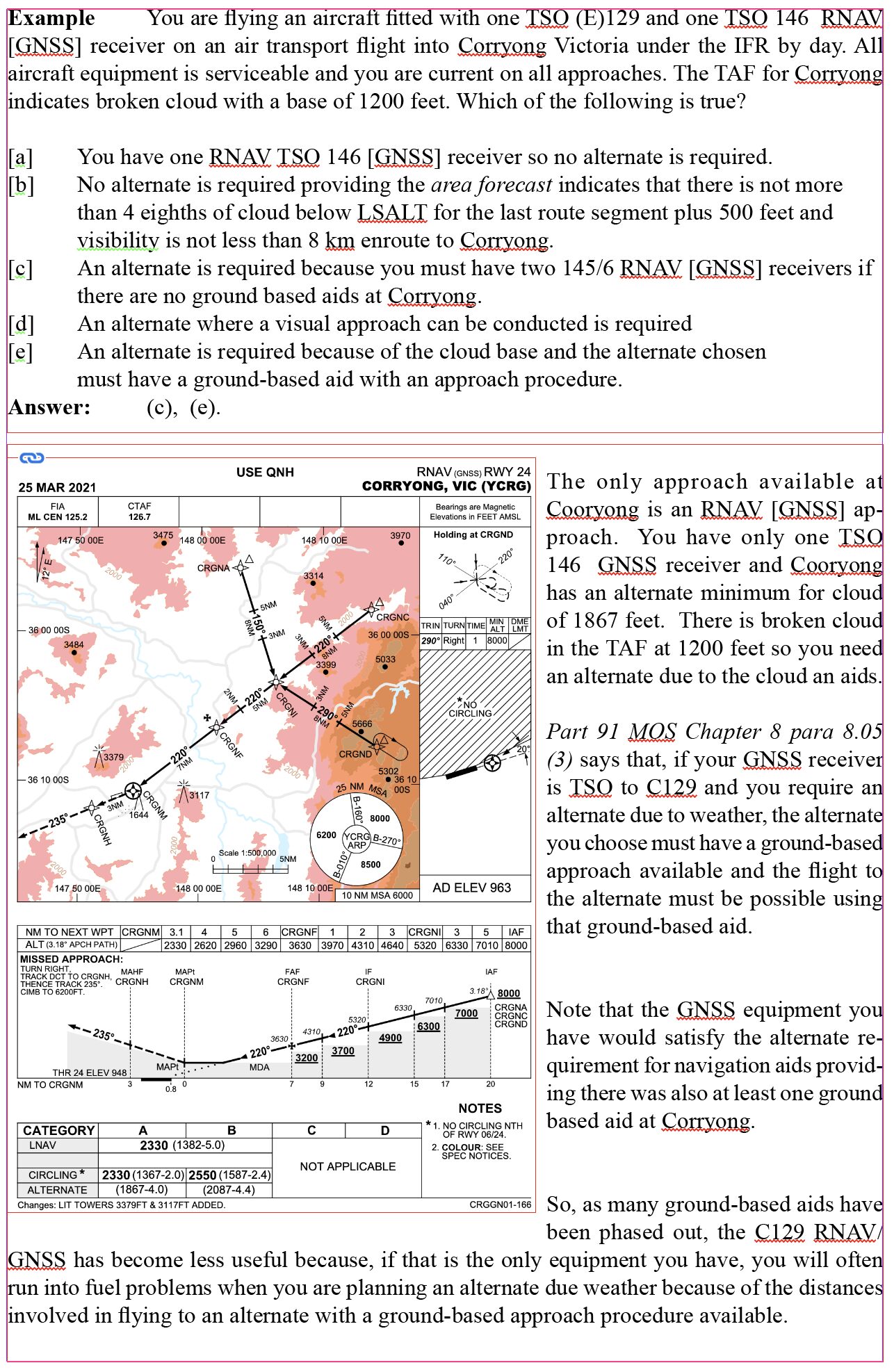
Page 155 has been rewritten. Page 155
16.01.2024
Several recent changes to ERSA have given rise to the errata below. Mainly in preferred routes.
Page 171 Q1 Replace ‘Coonabaraban’ with ‘Cooma Snowy Mountains, Page 182 The validity of the TAF3 should be 0300/0100. Page 191 Revision Exercise 4. The alternate minima for YSSY is now 1189 ft. (doesn’t change the answer). Page 203. Now route via MAKOR Page 206 Q 1 W220 has been replaced by V285 and flight to be conducted at A100, not A080. Q 2 YSSY – YCFS is now DCT TESAT H252 UPENX H140 MALTA BANDA CFS CFS DCT. Q3 Change of waypoints. Now OTLIN V543 DUUKE Q511 RIC V11 BK. Q7 frequency changed to 120.75. Page 207 Q 10 Frequency changed to 135.7.
31.07.2023
Page 193. The question text now inlcudes an extract from the GAF as follows. “The GAF sub-division C (around Kalumburu), forecasts cloud as BKN with a base of 1000 feet and tops of 2000 feet)”. Page 195 now includes the following expanded explanation for the application of ‘contingency fuel’ “Minimum fuel required on departure Griffith would normally be: 31 x 1.1 + 18 + 45 + 30. However 10% of 31 is only 3.1 minutes. The contingency fuel is the lesser of 10% of the trip fuel or 5 minutes whichever is the greatest. So, in this case you must use 5 minutes. So min fuel = 31 + 5 + 18 + 45 + 30 = 129 minutes”. Part 135 MOS 7.02 (b).
28.07.2023
Page 334 Set 7 Question 9. Amend answer choice (d) to read “Continue the approach on a track of 169°M to the circling area and join a right downwind for runway 34.”
30.6.2023
Operational Met Assessment Test. Page 365 Answer to Question 6 is (c). The answer to Question 7 is (d). Question 8 has fallen victim to the document changes. It has been deleted.
16.06.2023
Page 103 Exercise 2.11 Question 5 Rooks has been changed to Uprun. Question 6 Minni has been changed to Ensid. The answers are still correct.
17.05.2023
Page 315 Question No 34. Add to the question text “You are tracking on the RWY 19 LOC not below the glide path and with less than full scale deflection on the glide path indicator”. The answer remains 10nm.
17.05.2023
Page338 Revision Question Set 10 Question No 2. The route from Smithton to Hobart is now called T234. The reporting point ‘Salem’ is now called ‘Urben’. Change any reference to ‘Salem’ to ‘Urben’. The answer is Urben only.
16.05.2023
Page 334. CIR Revision Questions – SET 7 Question 9
The answer is [d] Continue the approach on a track of 169°M to the circling area
and overfly and join a left down wind for runway 16
11.05.2023
Page 348 Test No 2. The name of the STAR has changed from WARREN SEVEN to WARREN EIGHT. There is no obvious change to the procedure so the answer to the question remains the same.
09.05.2023
Page 217. Exercise 3.2 Question No 30 Answer. The explanation is correct, but the answer identifier should be changed to (d).
02.05.2023
Page 188
The question text has been amended as follows. The answer remains the same. 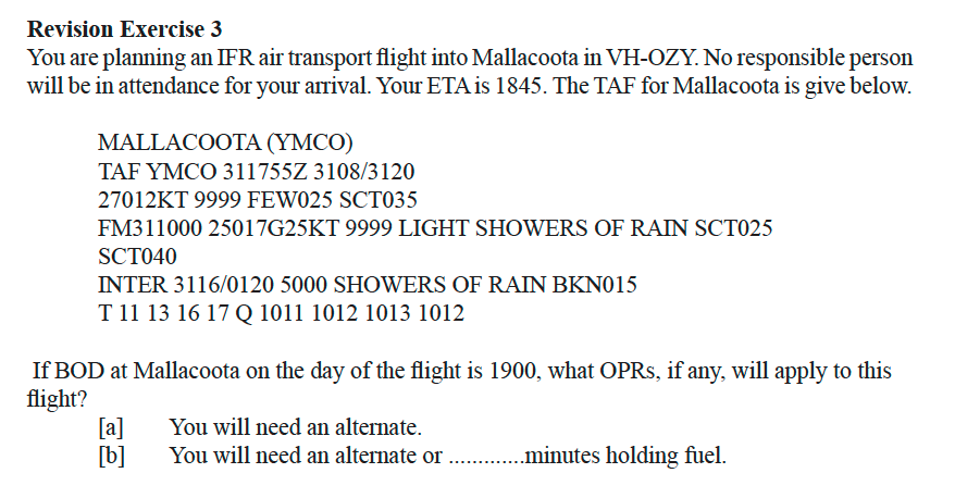
02/05/2023
Page 155 Example: You are flying an aircraft ftted with two TSO (E)145 RNAV [GNSS] receivers
Should read:
Example: You are flying an aircraft ftted with one TSO (E)129 RNAV [GNSS] and one TSO 146 [GNSS] receivers
21.4.2023
Page 194. Line beginning “Therefore minimum fuel required” 105.4 should be changed to 205.4 (call it 206).
03.04.2023
Page 145 Revision questions 2.1 Question 2 answer [d] Air transport needs two RNAV GNSS recievers (other than TSO 129)
31.01.2023
IREX question based on the Kununurra RWY 12 NDB approach. Typo. 208 should be 028 and answer should be 358°M
14.12.2022
Change answer (b) to 480ft. It is the glide slope indicator that has failed. You will still have a DME readout from the RNAV/GNSS. A DME is required for this approach, so you can continue with the LOC approach. Answer according to the current DAP is 460ft.
16.11.2022
Page V in the intro to the book. Permitted materials includes Part 135 MOS. It was omitted in the last print of the book.
6.7.2022
Page 194. Last line in the Kalumburu question answer. (“call it 206” should read “call it 106”)
30.06.2022
Page 152 beside the image of the ERC chart for Caiguna, The grid lowest safe altitude has been changed to 1900 feet. So, once you are established within the grid containing Caiguna, you may descend to 1900 feet and, providing you have a visibility of 5km, you may commence a visual approach.
07.06.2022
Page 171 Question No 1. Change destination to Cooma-Snowy Mountains. Coonabarabran now has no ground-based aid.
03.06.2022
Page 119. first dot point. Replace SID with Instrument Approach Procedure. Page 134. last paragraph. 600nm should be 575nm. Page 143. Question 10. V112 has been amended in the ERC to V656.
23.05.2022
Page 145 Answer to question 9 is now (a). The rated coverage of the Emerald NDB has changed. It is now 60nm not 40nm. The flight can be planned by reference to ground-based aids only.
02.02.2022
Page 142 Revision Exercise 2.3 Question 1. Add ‘in a multi-crew aircraft’ to the end of the question stem after ‘in IMC”.
20.01.2022
Page 103 Exercise 2.1. The first three questions have been amended. See attached below the amended Questions and Answers 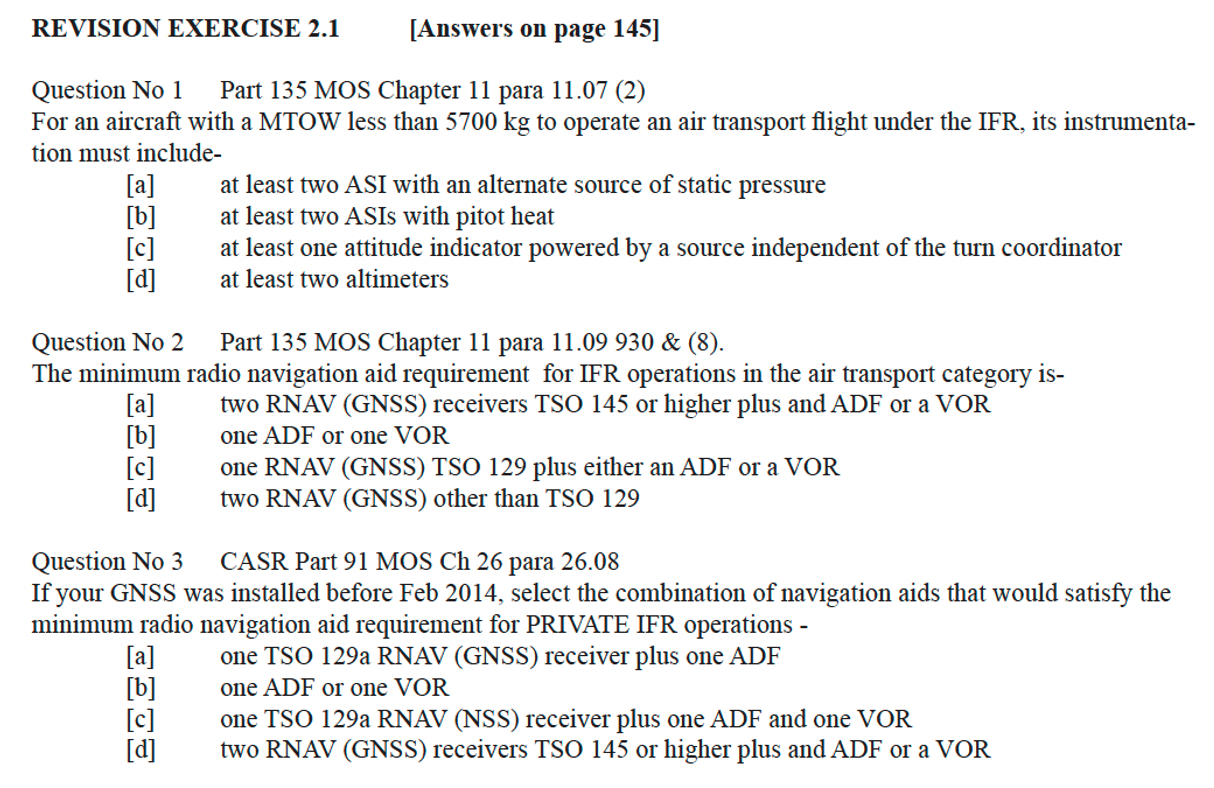
20.01.2022
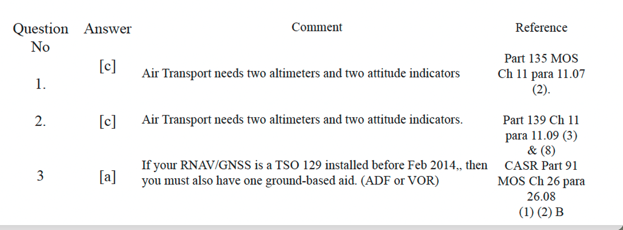
06.12.2021
Single pilot air transport flights require two altimeters and two attitude indicators. CASR 135 MOS 11.07. (1) (2) (3).
06.12.2021
Some of the questions in the IREX book make reference to ground operation of radar equippment. The answers were based on the assumption that CAO 20.9 was still in force. That is not correct. Only reference to operation of electronic epuippment in the vicinity if refuelling points is in CASR 91.485 (3) (c) (ii), which says 6m is the minimum distance at which electronic equipment can be operated from refuelling points.
02.12.2021
The required aeronautical knowledge for the CASA IREX is largely unchanged. However there have been some changes affecting the document references where the information can be found. The links below will assist in finding the new references that affect the IREX study guide. IREX_AIP_REFERENCES.pdf NEW_IREX_MOS_REFERENCES.pdf
11.08.2021
Page 319 Answers to Question 4 Set 2 Revision Exercises. Replace existiing answer with:
Kerang has a GNSS approach with alternate minima specified as 1116 ft ceiling and minimum visibility of 4.4 km. There is no TAF available for Kerang but you can use the Area QNH inste (AIP ENR 1.5 para 5.3.4. So use a ceiling of 1165 and 4.4 visibility. Also be careful of the use of ‘and’ or ‘or’. if either the ceiling or visibility is below the minimum, an alternate is required
06.04.2021
The latest issue of the AIP (March 2021) has required a large number of
changes to the references in our study guides.
There have been no signifcant changes to the actual wording, but the
section and paragraph numbers have changed rather dramatically.
As you can imagine, this has presented us with a major task of updating
hundreds of references across all of the publications plus hundreds of
on-line practice exam questions
.
This document LATEST REFERENCE CHANGES.pdf contains the relevant changes to the
INSTRUMENT RATING STUDY GUIDE.
27.01.2021
Page 358 Question 1 AIP GEN 3.5 para 3.7.4 now reads AIP ENR 3.5 para 3.6.4
Question 2 AIP GEN 3.5 para 3.7.6 now reads AIP ENR 3.5 para 3.6.6
Question 3 AIP GEN 3.5 para 3.7.4 now reads AIP ENR 3.5 para 3.6.4
Question 4 AIP GEN 3.5 para 3.7.1 now reads AIP ENR 3.5 para 3.6.1
Question 5 AIP GEN 3.5 para 13 now reads AIP ENR 3.5 para 12
Question 6 AIP GEN 3.5 para 3.7.1 now reads AIP ENR 3.5 para 3.6.1
Question 7 AIP GEN 3.5 para 3.8 & 13 now reads AIP ENR 3.5 para 3.6 & 12
Question 9 AIP GEN 3.5 para 12.17.2 now reads AIP ENR 3.5 para 12.18.2
Question 10 AIP GEN 3.5 para 12.16 now reads AIP ENR 3.5 para 12.17
Question 16 AIP GEN 3.5 para 3.6 now reads AIP ENR 3.5 para 3.4.3
Question 20 AIP GEN 3.5 para 7.3.4 now reads AIP ENR 3.5 para 7.2.4
Question 21 AIP GEN 3.5 para 3.6.4 now reads AIP ENR 3.5 para 3.5.4
Question 22 AIP GEN 3.5 para 3.6.4 now reads AIP ENR 3.5 para 3.4.3 (answer changed to (a) )
Question 25 AIP GEN 3.5 para 3.7.5 now reads AIP ENR 3.5 para 3.6.5
14.11.2020 The PDF in this link replaces the section on TTF’s with it replacement the TAF3
16.07.2020
Page 194 Question No 5. The chart has changed since this question was written. It has been replaced with “YBSU to YBBN. Correct answer VIA V217 GAYLA V307 BN DCT
01.05.2020
Page 173 Paragraph 1. The alternate minima 1087 and 4.4 for Brisbane is now 1135 and 4.4
27.05.2020
Page 323 CIR REVISION QUESTIONS SET 8
Question 9 answer (a) is now “carry out a missed approach”
24.07.2019
Page 286 & 287
Marker Beacons are no longer used in Australian ILS procedures. These pages have been replaced with more information on ILS. approaches. Download here.
30.01.2019
Page 181 Changed minimum fuel required equation to reflect the changed fuel requirements ie: no variable reserve on alternates
Therefore minimum fuel required = [84 +38] x 1.1+ 45 + 30 = 210 minutes
is now
Therefore minimum fuel required = [84 x 1.1] + 38+ 45 + 30 = 205 minutes
Page 183 [31 +18] x 1.1 + 45 + 30 = 127 minutes.
is now
10% of 30 is less than 5min. So add 5 min for variable reserve. 31 + 5 + 18 + 45 + 30 = 129 minutes
30.01.2019
Page 181 Changed minimum fuel required equation to reflect the changed fuel requirements ie; no variable reserve on alternates
Therefore minimum fuel required = [85 +38] x 1.1+ 45 + 30 = 207 minutes
is now
Therefore minimum fuel required = [85 x 1.1] + 38+ 45 + 30 = 207 minutes
Page 183 [31 +18] x 1.1 + 45 + 30 = 127 minutes.
is now
[31 x 1.1] + 18 + 45 + 30 = 127 minutes.